| APPLICABILITY |
| APPLICATIONS |
+386 41 353 392
LARGER AREA PROJECTS
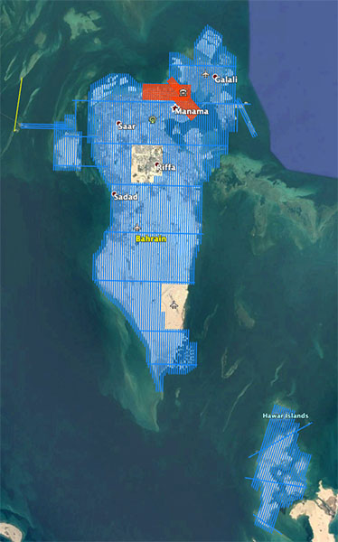
AERIAL SURVEY IN THE KINGDOM OF BAHRAIN
AeroMap
After invitation and in cooperation with the company AeroMap from Austria, we performed aerial survey RGB/NIR/LIDAR of the entire area of the Kingdom of Bahrain in record time in December, with the exception of two military areas. The country needs a 3D model due to rising sea levels as a result of climate change.The highest point is only 134 m, so most urban areas will be severely affected by sea level rise. Between 30.11.20 and 3.12.20 we flew the plane via Crete, Hurghada to the capital Manama, where we surveyed the country in 7 flight days. On December 17.2020, we were already back in Slovenia.

Thermographic AERIAL SURVEYS of the district heating network 2014/2015
Client: Energetika Ljubljana, d.o.o.
The project included thermographic aerial survey of the district heating network Energetika Ljubljana with thermographic camera from the air, making thermograms and IR-DOF. District heating networks Energetika Ljubljana stretches in the City of Ljubljana with a total length of 260 km and is in large part carried out underground in hot water with built-in kinetic and subsequently insulated steel pipes or by direct laying of pre-insulated pipes in the ground. To a lesser extent hot water is conducted above ground or underground with hot water collectors. Aerial Survey was carried out in suitable weather conditions, when the outdoor temperature was below 0° C, in the size of a resolution of one "pixel" of 20 cm.
Based on the thermograms we manufactured and delivered to the client color IR DOF, which is placed in the space according to the projection Gauss Krueger - Ljubljana and the European coordinate system (ETRS). The client also received thermograms - color infrared imagery of the entire district heating network of air in a form that can be reviewed and processed in a suitable software tool. Clips of thermograms have proven to be 100% accurate method to detect defects in the district heating network.


